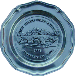
Van Metre Ford Stone Bridge
On List of National Register of Historic Places.
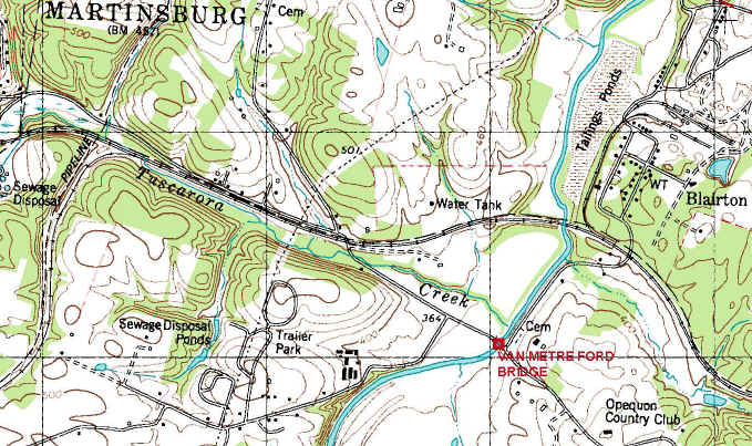
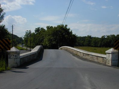
Location: Across Opequon Creek on County Route 36, East of Martinsburg, Berkeley Co., West Virginia. Topo. Map
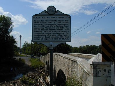
Description: This three-span, stone-arch bridge was built in 1832 by Silas Harry under contract with the Berkeley County Court. It was constructed in order to eliminate the fording of Opequon Creek when traveling on the Warm Springs Road.
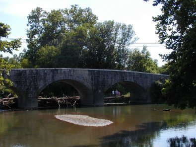
The bridge is 165 feet long and is built of uncoursed ashlar limestone masonry. Each of the three segmental arches, delineated with smooth-surfaced, but irregular width, voussoirs, springs from low, round-ended piers that have cone-shaped buttresses carried into the solid masonry spandrels. The center arch spans 32 feet while each of the end arches spans 29.6 feet.
Parapet walls appear to have had cement capping added at some later time. Low pylons, also capped with cement, termite the parapet walls at the approaches to the bridge. In plan, the structure is wider at the ends (22 feet) then at the center (16 feet). The stone work in the piers and buttresses as well as in the voussoirs is especially precise. Mortar erosion over the years has revealed closely fit joints.
The only changes to the bridge have been resurfacing of the road and repair to the walls above the road line where automobile accidents have caused destruction. Although worn, the stonework has held up superbly to the stresses of load and forces of the elements.
Statement Of Significance: Van Metre Ford Stone Bridge in Berkeley County, West Virginia, played a significant part in the development of the local transportation system and helped spur commerce and communication by making the crossing of Opequon Creek easier and less expensive. Construction by a private bridge builder (a stone mason no doubt) under the auspices and guidance of a commission appointed by the county court, the method of proceeding with this type of improvement was important in its own right as indicative of the role of government in the field of transportation regulation and development. The product was a structure of utility and beauty, for the rise in height and constriction in width toward the center combined with the stout but graceful buttresses and purposeful but pleasing arches to provide a water crossing able to carry the heaviest load through what has always been a picturesque setting.
The opening of new land and the building of a new nation after the Revolutionary War found a literal and figurative barrier in the lengthy chain of mountains called the Appalachians, even while the cry for internal improvements emphasized the development pf greater commercial accessibility to the hinterland. The first phase of the process, in many instances, was reaching the mountains from the cities and waterways of the eastern coastal areas. Roads, canals and eventually railroads became enterprises of benefit to more than just the subscribers to each effort, and the undertakings required the outlays of groups rather than individuals. This basically took the form of a variety of private quasi-public and public companies, but all transportation development came in one way or another to call upon the resources of local governments.
Major links like the National Road, Chesapeake and Ohio Canal and Baltimore and Ohio Railroad would be the outstanding and primary objectives, yet it was the local turnpike, waterway and railroad spur that touched small farmers, craftsmen and general public most directly. Van Metre Ford Stone Bridge, though a minor, almost insignificant, element in the opening of the interior, represents effort on the local level that complemented the grand design.
Land along Opequon Creek where the bridge stands had been in Van Metre hands since the 1730s, and the Warm Springs Road traversed it early on. This road apparently stretched the distance between Alexandria and the Warm Springs (Bath or Berkeley Springs today), the latter a place frequented because of its quality mineral waters. Probably beginning as little more than a path, the road eventually became a main east-west artery of the area and carried much local commerce and communication. By the nineteenth century there was a need for a set and improved route to serve the visitors to the springs, travelers to eastern cities, mails, drovers headed for markets and the growing amount of local business enterprise. Among improvements decided upon was the upgrading of fords and construction of permanent bridges, and one of the latter was scheduled for the Opequon at the old Van Metre Ford.
Not being a turnpike or legislated highway that had access to funds from subscriptions, special appropriations or lotteries, the Warm Springs Road through Berkeley County had to be improved at local expense. During the early 1830s, the country court established a commission composed of James Doll, Daniel Burkhart and Jacob Vandoren to study the Van Metre crossing and contract for the erection of a stone bridge. In 1832 they reported that a contract had been agreed upon with Silas Harry of Pennsylvania (he had done some bridge building in nearby Maryland). The commissioners were given $850 early in the year and told to obtain stone, timber and other materials necessary. In late April, a local newspaper reported that the bridge would cost $3700, but the matter-of-fact way it was mentioned indicates that the sum, apparently raised by a county levy, neither was viewed as excessive nor the project inappropriate.
Harry used limestone, a common building material of the area, to construct the triple-arch span. Engineering skills in the use of stone for bridges had evolved over a fairly long period, but the arches became wider and higher and piers narrower as new techniques developed and understanding of stresses and pressures progressed. In the Van Metre Bridge, Harry translated engineering skills into a attractive passage over the Opequon. The stonework itself was well executed, and the varied sizes of the blocks has provided an interesting backdrop to the seemingly smooth and proportioned voussoirs of the arches. All is complemented by the cone-shaped buttresses on the piers to either side of the main arch.
Since 1882 the Van Metre Ford Stone Bridge has served the area well, at first as a major crossing of an important waterway on a primary transportation route and more recently as a convenient (though narrow) crossing of a small stream on a secondary road. Modern highway development and bridge engineering have passed it by, but the strength of its stout construction has defied the destructive forces of the elements and made-made obstacles. Utility in purpose has now been transcended by attractiveness in setting and design in stone to make the structure a landmark unique in the area.
Copy of the National Register Of Historic Places Inventory -- Nomination Form. Prepared by: James E. Harding, Historian - October 7, 1976