Fort Pleasant
On List of National Register of Historic Places.
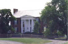
Location: Old Fields, Hardy County, West Virginia. Topo. Map Sketch of Military Fort Pleasant
Description: The house is a massive double-chimney styled building made of brick from clay on the Fort Pleasant farm. The style of the house is severe Federal with the country touches that come from building with semi-skilled help far from cities elegancies. The 18 remaining rooms are an architectural unit with the exception of the two room half basement half-house section of a much earlier date.
The main house was complete by the end of the 18th century and early use of a massive colonnade is distinctive. Inspection of the front portico rails and wash boards, simple decorated door frames and magnificently elegant Federal style mantels. The stair runs up three floors to the attic with a very plain Federal style banister. The ceilings in the front section are 14 feet high, the large paned windows make the company rooms light and airy.
When the Renick Williams' family purchased the farm in 1969 the house had been allowed to decline. The old bachelor quarter had disappeared, and the rest of the house showed the signs of age unrelieved by wealth.
The Williams are being extremely careful in their restoration, and are proceeding at a slow pace because of high cost of the initial repairs.
Statement Of Significance: The present "Fort Pleasant" is built on the site of Isaac Vanmeter's home and fortress which were constructed of logs around 1744. The fort was one in a chain running north and south along the Allegheny frontier. These were designed by George Washington for the protection of settlers during Indian unrest which reached a local climax in the years 1756-1758. From the Fort Pleasant sanctuary men went out on many occasions to attack and disperse threatening Indians. Isaac Van Meter himself was killed by Indians while he was working in his fields in 1757.
During his work as a surveyor for Lord Fairfax, George Washington called at Fort Pleasant, and records in his journal that he visited with "Mr. Vanmetrise." Contacts between the two were less than happy; Lord Fairfax claimed the Vanmeter tract as a part of his South Branch Manor, included in the original "Northern Neck" grant from Charles II. Van Meter claimed that his lands were not included in the Fairfax grant; rather, that they were granted separately by the Virginia Council in 1730. Resulting litigation from the depute went on for many years, and finally was settled after the Revolutionary War by a court decree upholding the Van Meter heirs in their claim.
Isaac's son, Garrett, improved the Van Meter lands by allowing the removal of the old fort and cabin, and replaced it by a strong brick structure, half below ground and half above, and designed for defense. This stronghold, portions still extant, is an awkward, crudely fashioned building linked to the rest of the existing Fort Pleasant by a series of enclosed steps. The stronghold was a center of activity during the bloody "Battle of the Trough", an engagement between Indians and settlers in 1756.
Garrett Van Meter's son, Isaac, married Elizabeth Inskeep, daughter of a pioneer family in the South Branch of the Potomac Valley. Together they planned and built the beautiful home, "Fort Pleasant", on the site of the old fort that bore that name. Their residence was soon recognized as one of the "great houses" in the South Branch Valley.
Fort Pleasant is situated just above "The Trough", a natural gateway to the South Branch Valley. The first highway to the upper valley passed nearby, and to it came soldiers, surveyors, hunters and trappers, Indian traders, and such men of affairs as Christopher Gist. It was a center of activity during the Revolution, during the years of westward expansion, and through the Civil War and later conflicts in which the nation has been engaged. The purpose of the present owners is to preserve and restore it with utmost fidelity to the original residence structure.
Copy of National Register of Historic
Places Inventory - Nomination Form. Prepared by:
Nancy Snider, Field Research Agent, August 1972
History of Fort Pleasant as written in "Annual Report West Virginia Antiquities Commission - 1971.
Accounts differ, but tradition has it that the first white person to see the South Branch Valley of the Potomac was John Van Metre, a New York fur trader. Van Metre and a Delaware war party were supposed to have made a trip into the valley around 1725. The Delaware's wished to penetrate into the Catawba country further south. Unfortunately, for their plans, the Catawba met and defeated the Delaware's near Franklin in Pendleton County and the Delaware's were forced to retreat back up the road that followed the South Branch Valley, he must have taken time to appreciate the possibilities the valley offered. He is supposed to have told his two sons, Isaac and John, that "the lands immediately above the Trough were the finest body of land he had ever discovered in all his travels."
In 1730 the Virginia Council confirmed a land grant of 40,000 acres. Part of this land, 20,000 acres, went to the elder John Van Metre and was an area bounded by the Shenandoah on the east, the Opequon on the west, the Potomac on the north, and extended as far south as the southern branch of the Opequon. John Van Metre, the son, immediately settled on his land and Van Metre's have been in the Shenandoah Valley ever since. Isaac, the other brother, traveled into the South Branch Valley to blaze the extent of his claim for an equal 20,000 acres. In 1736, he marked his claim and went back to New Jersey to arrange to move to South Branch.
Arrangements must have been cumbersome because it was not until 1740 that Isaac again ventured down into the South Branch Valley. When he got to his claim, he found that a man named Coburn had settled there and made improvements. Improvements were usually defined as fences, barns, cabins, clearing of land and the planting of crops, a not inconsequential effort for that period. It is commendable that Isaac Van Meter bought out Coburn, evidently paying him for this tremendous work he had done. Finally, in 1744, Isaac Van Meter's pack train and wagons lumbered down from New Jersey with his family and he built a fort nearby for protection.
Isaac was evidently pleased with his home and fort for he named them both Fort Pleasant. The house and fort, built on a gentle rise overlooking the wide open fields stretching south down the valley must have afforded a satisfying view.
In his journal of 1748 Washington described his journey into the South Branch over 40 miles "of the worst road that was ever trod by man or beast." It must have been Isaac that he spoke with "about the intended work of lots." George was then a teenager of 16 years, and he had not gotten things exactly right. He called the owner of the land Henry Vanmetriss. Henry was a young son of Isaac and not the owner. He did give the Van Meter place its proper location at Old Fields at the head of the Trough.
The cabin and fort must have been too small to hold the surveying pary because George Washington complains in his diary that the entire time he was surveying in the South Branch, from March 27 to April 8, he slept once indoors.
Isaac may not have been very hospitable either. The purpose of the survey George and his party were running was to determine what people had settled illegally in the lands owned by Lord Fairfax. The grant given to Lord Fairfax by a grateful Charles II, overrode previous grants and gifts of land with a carelessness that made many loyal colonial angry. Isaac's grant of land by the Royal Council of Virginia was imposing, for the Council acted "in the King's name" but it lost some authority when matched with a similar claim on the same land that came from the King of England himself.
In 1744, a later Lord Fairfax presented himself to the Privy Council to determine the extent of his long ignored colonial holdings. He strongly was opposed by wealthy Virginia interests who already owned lands within the boundary of the Fairfax Grant. The agreement succeeded and it was agreed upon by both sides that Fairfax owned all the lands between the North Branch of the Potomac and the head springs of the Rapidan. Fairfax agreed to recognize all royal grants already given, waive all past due quitrents, and that he could choose or not choose to recognize any other grants or patents. Needless to say, Fairfax did not choose to recognize many patents. In fact, he hired many survey parties, one of which was the party George Washington accompanied down that "worst road." These surveyors were commissioned to determine who was squatting on his land and how much land they had taken. Meanwhile, Isaac Van Meter was prospering on his lands, secure in the belief that he was owner of the land. But on March 27, 1748, George Washington and Squire Fairfax, (a cousin of Lord Fairfax), arrived to assert their own claims. Isaac Van Meter's "Fort Pleasant" became listed on the Fairfax plat and quitrent rolls as Tract 1 in the South Branch Manor of the Fairfax Grant.
1756-1758 were years of bloody Indian raids in the South Branch Valley. The fort at Fort Pleasant had been rebuilt and strengthened by a large wooden stockade with a blockhouse at each corner. Stationed under the command of a British officer, Captain Wagner.
During the late late summer of 1756, a Mrs. Brake was killed and a Mrs. Neff taken prisoner by Indians on the South Fork about 15 miles above Moorefield. When the Indians camped that night, Mrs. Neff escaped and ran to nearby Fort Buttermilk with a warning of the Indian menace. Eighteen men from Fort Buttermilk left the fort to seek suitable revenge. They tracked the Indians into the deep canyon, known as the Trough, downriver from Fort Pleasant. They found the Indians camped on a strip of land near the turbulent, rain-swollen river. The frontiersmen decided to climb up the rocky ridge above the Indian camp and to work down the ridge until they had the Indians cornered between them and the river. The plan might have been successful had it not been for an accident. The climb up the other side of the hill to the top of the ridge was successful; there was no alarm in the Indian camp. When the men began to climb down the rocky cliff a little dog that had followed one of the Fort Buttermilk men saw a rabbit and ran yelping down the ridge. The Indians woke quickly and reversed the frontiersmen's plan. Some of the Indians climbed up to the top of the ridge and began firing down on the settlers. The battle went on for two hours. The settlers who were able slipped into the river to swim for their lives against the current of the Trough and to run the remaining distance of one and one-half miles to Fort Pleasant. The British officer, Captain Wagner, would not send help to the men trapped on the cliff in the Trough and he wouldn't open the gate for the survivors, who later sought shelter by running two miles farther up the valley to Lynches' blockhouse.
When he heard gunfire that day, Isaac Van Meter rode to a hill nearer the Trough and there he observed part of the battle. He rode back into Fort Pleasant with the news. The pioneer men and their families that were seeking safety within the fort wanted to help the men of Fort Buttermilk, but Captain Wagner would not let them leave.
In the next year, 1757, Isaac Van Meter was killed by the Indians while he was out working in his fields. He is buried about 150 feet below the crest of the hill on which stood his Fort Pleasant.
During the same year as the Battle of the Trough, 1756, a young boy, Robert Higgins, was sent out from Fort Pleasant to get water from the spring at the bottom of the hill. He did not wish to go alone, since the Indians had been seen near the fort. Robert persuaded another boy to go with him to the spring. After filling their buckets, they ran back up the hill. Robert was ahead by 30 yards when he heard the other boy scream. Higgins made it back to the fort; the other boy was captured and taken to the Indian settlements on the Ohio River. Some years after the war was over, he returned.
The Van Meter lands passed on to Garrett Van Meter, Isaac's son, a practical farmer who used the Van Meter lands and the relatively quiet period after the French and Indian War to amass a fortune in cattle and horses. Garrett pioneered the way for cattle barons of the early 19th Century who made South Branch Valley beef so famous that even young Queen Victoria was reported to have preferred it "above all other."
During Garrett's lifetime, the house we now know as "Fort Pleasant" began to take form. The brick stronghold was built without style, crudely, and with no attempt at any beauty, only solidarity. The windows are at eye level from a standing position.
It is difficult to arrive at any clear picture of Garrett Van Meter's character. One can speculate from his will and estate inventory that he was one of the first of the men of the valley to begin caring for and feeding cattle during the winter. The South Branch cattle culture involved fencing the animals in lush pasture and feeding them twice daily on corn. The cattle were no longer forced to range in the winter for their food, to emerge in the spring rough, raw, and stringy. Instead, the cattle of the South Branch were prime animals, which brought a premium price of 10 pounds per head as opposed to the common cattle price of 2 pounds to 3 pounds per head. The long horn English breed called Patton Cattle was popular in the valley and had been brought into the area by Matthew Patton of Pendleton County.
Garrett carefully provided for his wife, Ann, in his will. He gave her a dower third and no more. Since Ann could not read or write, all documents she required to sign had a shaky X. Garrett wisely instructed his sons to care for their mother and she evidently lived a comfortable life until her death in 1805. Her estate inventory of household goods was valued at $425.50, all of which she left divided equally between her sons and s daughter, Ann Van Metre Seymour. She did leave her set of silver teaspoons to her granddaughter, Ann Sibley.
Judging from the inventory of his property after his death in 1788, Garrett was a man of property. He had 45 horses, some of which were valued at 30 pounds to 60 pounds each. This didn't count one group pf horses that were sold before the inventory for 90 pounds for the lot. He had 114 head of cattle, 23 steers, and one lot of 25 cows had been sold before inventory. The premium price of 10 pounds per head gives some indication of Garrett's wealth. There were 12 salves who were named in the inventory. In an understanding gesture, Garrett left his whiskey still to both sons, Isaac and Jacob, to divide the profits of this enterprise between them. Thoughtfully include in the inventory were many cases of empty bottles.
The back section of Fort Pleasant, now torn down, with its great single log-burning fireplace, used to be called the "bachelor quarter." It was attached to the big house but not linked the the rest of the house by a door. It seems a good way to take care of an indomitable old women who lived seventeen years longer and who was granted Garrett's house for as long as she lived. It may be that the "bachelor quarter" was Ann Van Meter's house, separated from the great house Isaac began building, but close at hand. Garrett willed the lands to his son, Isaac, and the house to him on the death of his mother.
Isaac was 27 years old when his father died. He had made a successful marriage to Elizabeth Inskeep. His bride deserved the best so he began building the elegant Federal style home that is now called "Fort Pleasant". The bricks were made on site from suitable clay; window cornices were made from a more orange, smooth-faced, brick. The outside of the house has massive double chimneys at the gable ends of the front section of the house. There was a balcony on the second floor of the colonnade, reached by a door from the second floor hall.
The eighteen-room house now standing was complete; nothing has been added. The foundation and walls are of brick with rises above the cellar from a brick base laid on the ground. The load-bearing interior walls are also brick. The show rooms are large with many-paned high windows. Fireplaces throughout the house have refined Federal mantels and openings large enough for logs. The rooms have no cornices but each has a chair rail around. The floors are polished pine. In the front hall, a restrained and plain Federal staircase runs curving to the attic.
An interesting feature of the stairway from the landing between the second and third floors is that it does not fit. The stairway spills down from the landing onto the second floor, not at the beginning of that floor but far out into the second floor hall. The banister follows the stair and leaves an area of floor space some three square feet between the banister and the stairwell. A large unfinished room is on the right side of the front door. The room was builder-finished but never decorated. Someone in Victorian times put up a paper cornice and some half-hearted wallpaper, but even that was not complete. The fireplace mantels were painted black, but the rest of the woodwork had primer only. By evidence of the finger prints on the doors and walls, the did have use. It was the playroom of generations of Van Metre's.
Isaac and his wife were leaders of society. He represented Hardy County in the state legislature at Richmond and was respectfully called Colonel Van Meter by his neighbors. To the doric columned portico came the famous and would be famous. One day in 1796, a messenger brought news that the Fairfax claim to his land had been bought by a group of three; Chief Justice John Marshall, General Henry Lee (Robert E. Lee's father). and Raleigh Colston. He was told he could acquire free title to the lands, and in 1804 he bought the lands outright, more than 70 years after the Council at Williamsburg had given title to his grandfather. At long last, the Van Meter's owned their own lands.
For additional military history of Fort Pleasant click here.